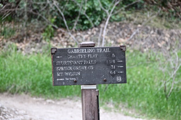
Over Easter Weekend my friend and I decided to backpack the entire 28.5 miles of The Gabrielino Trail. Our plan was to spend 3-4 days on the trail depending on our progress and energy levels. We had a friend drop us off Friday afternoon at Chantry Flats where we started the first stretch of our hike to Spruce Grove Campground.
This section of the hike was not new to us, having been down if before to go camping at Spruce Grove in the past. When we got to the campground we found it fairly vacant, with only two other groups there. We were pleased to see it so empty and picked ourselves a nice spot near a fire pit and table.

Shortly after we finished setting up camp one more fellow hiked in and set up next to us. He was friendly and we chatted a while before going to bed. The next morning we awoke to the clamor of day hikers. We had a quick breakfast, packed up, and said goodbye to our new friend. The section we were planning to hike this day was going to be from Spruce Grove to Valley Forge Trail Camp. Our first goal of the day would be hiking over Newcomb Pass, something neither of us had ever done before. It was a nice day out, and the climb up towards the pass was pretty gradual and had a good amount of shade.

We found a picnic table at the top of the pass which was nice. We had a short break there, ate a couple CLIF BLOKS, then continued down the trail towards Devore Trail Camp. On our way down from the pass we came across Rincon-Redbox Road where we lost the trail for a minute. It just took us walking down the road a bit to find where the trail picked up again. There probably could have been a trail sign here to make it a little less confusing.

We continued our way down to Devore where we came across two other backpackers that had just been there for the night and were now heading to Spruce Grove. Bottoming out into Devore was real nice. I had really been looking forward to checking out this trail camp as well as West Fork.
There was only one couple camping there when we arrived. We made note of how awesome and beautiful Devore was, picturing ourselves camping there sometime in the future. Not today though, we continued onto West Fork. The trail over this stretch is a gradual climb upstream with a lot of creek crossings.

By the time we got to West Fork Campground we were ready for another break and an actual meal. When we arrived at the campground the whole place was very busy with campers and day hikers. We chatted with one of the other backpackers camping there and shared a pot of ramen before we hit the trail again. The trail became a little more uphill and also started becoming more exposed to the sun. Some parts we hiked through were previously burned, so there were not a lot of tall trees to provide shade.

Maybe I was just getting tired, but it seemed like a long slog until we finally arrived at Valley Forge. My feet were definitely hurting now and the first thing I did when I arrived was take my shoes off and lay down in a grassy field. We only saw one group of guys hanging out at the campground but they left shortly after we arrived. It looked like we were going to have the entire place to ourselves.

This was my second time visiting Valley Forge. The first time I hiked in from Red Box Junction for a quick one-nighter. I didn’t mind being back; it’s a great little backcounty campground. If you’ve ever been there before, you know there’s a little bridge across a small stream that leads you over to the “secret” campground. While exploring the area we found out that we were not alone, and that some other folks had beat us to the “secret” spot. It was a gorgeous day at the campground when we were there: the grass was green, flowers were in bloom, and there were butterflies and ladybugs everywhere. The whole area resembled a scene from a fairy-tale.

The next morning we headed out for Red Box where I had previously stashed some beers the weekend before. After locating them in the hiding spot where I had tucked them away, we took a break near the visitor center at Red Box. This is a great spot to stop for a break.
The visitor center at Red Box sells snacks and drinks, there is a potable water spigot, and also a payphone if you need to make a phone call. We took full advantage of these conveniences. It was nice to buy some snacks as we had not had a proper breakfast on this day. I made a phone call to my family to let them know we were doing well, and finally we refilled our water packs. With all that done, we started out for our next stop, Switzer Picnic Area.

This stretch of trail was all new to me. A lot of was all expose, but down hill and well maintained. It seems this section is popular among mountain bikers, so we had to watch out for them.

Although this section of the trail offered some great vistas, it was also in close proximity to the Angeles Crest Highway. There was a lot of motorist noise along the trail here which wasn’t something we were used to hearing. Despite the noise and getting hit by the sun, I mostly enjoyed this part of the trail. I may not have liked it so much if I was coming uphill though!

It was nice to finally cruise into the shaded tree canopy of the Switzer day use area. We took another break here and had another one of our beers to lighten our loads a bit. There were a lot of people at Switzer’s on this day (Sunday), which is not unusual for the weekend. If you’ve ever visited this area you know how popular it can be on a nice day. I was honestly happy to be hiking pass all the crowds and day-hikers back into the peaceful solitude of the mountains.

We passed by Comodore Camp, which really isn’t much of a campsite anymore. It was a possible location for us to camp if we really needed to, but we had good energy and it was still early in the day. At this point we were thinking we could either finish the rest of the trail today, or end up camping at Oakwilde if we got too worn out.

As we made our way down into the Arroyo Seco we came across a few obstacles. The first one was where part of the trail was very washed out on the side of a hill and we had to be careful crossing the landslide so we wouldn’t end up down the hill. At another part of the trail there were two large trees with dense branches which had fallen across the trail. There was no good way to get around them without going all the way down into the steep gorge below. We decided to climb over and through them, using the branches as a ladder. Some parts of the tree I cut through with my Leatherman to make it easier to pass our gear through. We had to hand our large packs over and through one by one. Eventually we made it past that last obstacle and it was smooth sailing from there, however the long day was starting to take it’s toll on us.

We were hoping to take a break at Oakwilde Camp since we were starting to feel tired from the long day of hiking but we must have passed it because we never saw it. I was a little disappointed we didn’t get to check out Oakwilde, but we decided to keep pushing onward despite being very worn out. We finally made it to Paul Little Picnic Area where we had a well deserved break. After one more break at Gould Mesa we pushed through the final part of the trail finally coming to it’s end near the NASA Jet Propulsion Laboratory.

We did this hike before the trail was officially completely opened. There is a closed section of trail between Switzer and Paul Little Picnic Area. The Gabrielino Trail is scheduled to be completely re-opened sometime in late 2018.
UPDATE: Portions of the trail are closed again. Check trail status before going.


